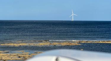
As offshore wind turbines continue to grow larger, with blade tips reaching +250 m high, there is a requirement to obtain accurate wind resource and site condition measurements at higher heights. Such wind data are often obtained using a floating LiDAR system (FLS), but the reference system is typically an offshore meteorological mast or a fixed LiDAR (commonly calibrated around 100 m height).
Previous work by the Offshore Wind Accelerator (OWA) revealed evidence of potential biases that could be introduced at higher heights by buoy motion, LiDAR characteristics, atmospheric gradients and combinations of these effects. Any such effects could bias P50 (50% exceedance probability) estimates in energy yield assessments or lead to an increase in uncertainty and hence a reduction in P90 (90% exceedance probability) estimates.
Building on previous OWA work, the Tall Floating LiDAR System Trial for Offshore wind (TaLiSman) project will carry out a comprehensive trial to deliver a body of evidence to support using floating LiDARs for measurements at high heights. The new knowledge can be used by wind farms developers to drive down uncertainties on their commercial projects and improve bankability. TaLiSman’s objectives include:
- Address the risks of using floating LiDAR data for measurements obtained at heights well above 100 m.
- Gather evidence to better understand the accuracy and validity of turbulence data from floating LiDARs.
To achieve this, the project will perform a detailed validation of several FLS using a combination of an IEC-compliant offshore met mast and dual Doppler scanning LiDARs, enabling a consistent assessment of performance and uncertainty up to heights above 250 m. This will also enable turbulence data to be collected and validated against a consistent reference up to these high heights.
The measurement campaign is taking place at ORE Catapult’s National Offshore Anemometry Hub (NOAH) met mast at Blyth in north-east England. The scanning LiDARs are supplied by EnBW. The installation, commissioning and decommissioning of the monitoring equipment as well as the monitoring activities and data analysis are to be conducted by Oldbaum Services and Fraunhofer IWES.
The measurement campaign has a duration of 6 months and includes data collection and analysis from the reference met mast, a continuous wave (ZX) and a pulsed vertical profiling (WindCube) LiDAR, two dual Doppler scanning LiDARs, several FLS and a ceilometer.