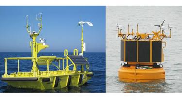
Floating LIDAR technology has the potential to replace meteorological met masts for the measurement of primary wind resource data – wind speed and wind direction for a fraction of the cost.
The Carbon Trust Offshore Wind Accelerator has published a roadmap for commercial acceptance of floating LIDAR technology. This document describes three stages of commercialisation in terms of accuracy and availability KPIs. It also explains how measurement uncertainties decrease as a floating LIDAR device moves from Stage 1 (baseline) through to Stage 2 (pre-commercial) and finally Stage 3 (commercial).
The report, prepared in close collaboration with GL Garrad Hassan DNV KEMA, Mott MacDonald, ECN and Frazer Nash Consultancy, is available for download here:
OWA roadmap for commercial acceptance of floating LIDAR technologies v1 (pdf)
Published 21 November 2013
The purpose of this document is to present a roadmap for floating LIDARs to become commercially accepted as a source of data to support financial investment decisions.
In order to support floating LIDAR suppliers to achieve this, the OWA will facilitate trials of floating LIDAR systems compared to meteorological masts within their portfolio of projects.


